Convection Cells and Global Weather Patterns
Weather is based on the relationship of the Sun to the Earth.
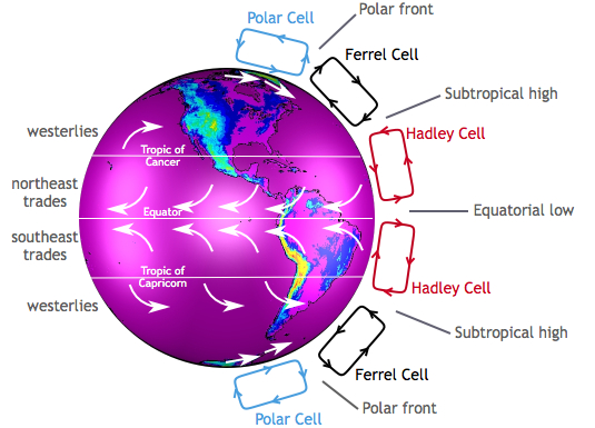
Hadley Cells
As seen in “Island in the Sun”, the rays of the sun heat the earth and the air above it. The more directly the rays of the sun impact the Earth, the more energy is transferred heating the Earth and the atmosphere above it.
The sun is located more or less over the equator. Because of this, the air near the equator is heated more causing it to rise vertically.
Heated air from the equator begins to move toward the poles and to cool. As the air cools, it begins to descend back to the Earth’s surface. The cooling air descends about latitude 30, causing a “pile” of extra air to end up at that location. This results in an area of higher pressure. Then, as the cooled air reaches the Earth’s surface it heads back to the equator. Filling in for the air that is heated and rising air.
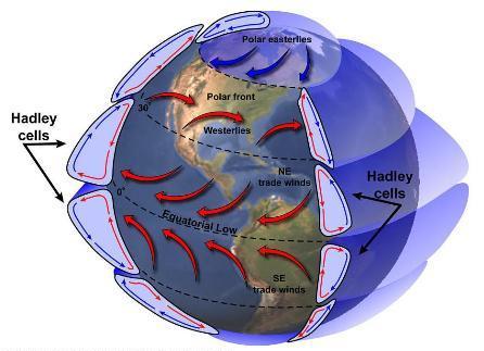
The Hadley cell forms a convection cell dominating lower latitude (0° to 30°) tropical and sub-tropical climates. Two other convection cells join, the Hadley Cell setting global circulation patterns into motion.
Polar Cell
The air at the poles is much colder than the air around latitude 60. Meaning, the air rises from around latitude 60 and travels toward the poles. Once over the poles, it sinks, forming the polar highs. At the surface air diverges out and away from the pole, back to latitude 60. The resulting convection cell is referred to as a Polar Cell
Kind of the same
In many ways, Hadley Cells and Polar Cells are similar. In both cases, air rises from a warmer location, travels north towards the pole, sinks, and finally travels away from the pole to its starting point. Convection cell rotation with both is the same direction.
In contrast, between the two is a cell rotating in the opposite direction.
Ferrel Cell
The sinking air from the Hadley Cell (near latitude 30) drags air beside it down, while air rising in the Polar Cell (about latitude 60) takes nearby air up with it. The rising air then moves away from the pole at high altitude. The opposite the direction of the other cells. On the other hand, the sinking air moves toward the pole along the surface of the Earth.
Click the image for a Global Circulation Video. (video under construction)
Global Wind Belts
As described in the video, there are three global wind belts north, and three south of the equator. Located close to the equator are the Trade Winds (also known as the Tropical Easterlies), blowing from east to west. Located from around 30° to 60°are the Prevailing Westerlies. Finally, north and south of 60° are the Polar Easterlies.
Bands of High and Low Pressure
A band of high pressure lies between the Hadley cells and Ferrel Cells. The high-pressure band is located about 30° North and South latitude. Each pole is the location of another high pressure area.
The equator and 50° to 60° North and South latitude are low pressure bands.
Associate hot, dry weather with high pressure. In contrast, rainy and stormy weather is associated with low pressure. The regions between 50° and 60° tend to have more precipitation due to more storms moving around the earth at these latitudes, especially along the west coast of continents. While many of the Earth’s desert areas are located along latitude 30°. Also, large high pressure areas are found in the middle of oceans at that latitude.
We look at high and low pressure, and the properties of each in a later lesson.
Seasonal Changes
One final topic before closing this lesson. The axis of the Earth does not sit straight up and down. It tilts in relationship to the sun at approximately 23.44°.
Due to the tilt of the Earth, the sun is directly over the equator only twice a year, on about March 20th and September 22nd. During the summer and winter, the sun slowly “moves” north and south of the equator to a maximum of 23.44° north on about June 21, and 23.44° south on about December 21 . The maximum latitude marking the sun’s location is known as the Tropic of Cancer in the north, and the Tropic of Capricorn in the south. The “tropics” lie between Tropic of Cancer and Tropic of Capricorn.
As the sun moves north and south of the equator, Hadley Cells and Ferrel Cells, as well as their associated high and low pressure systems move also. The perfect example is the semi-permanent North Pacific High. Centered about 30° north, the North Pacific High moves north in the summer to roughly 38°.
Watching this video demonstrates what happens by tracking water vapor in the atmosphere over the course of a year. Watch the top of South America. At the beginning and end of the video (winter time), the vapor trail is much lower than during the summer in the middle.