Line of Position
What is an LOP
In this topic, we discuss “Lines of Position.” A line of position (LOP) is a “line” to or around a target object. When an LOP is determined, you must be somewhere on that line. Because of this two LOPs provides an exact location. In other words, if you are somewhere along each of two different LOPs, you must be located at the intersection. In this case, “X” marks the spot.
An LOP can be found a number of different ways.
- Bearing to an object
- A Range (two objects in line with each other)
- Depth contour line on a chart
- Distance Off an Object
- Angle off the bow (AKA Relative Bearing)
- Radar Range
- Advancing a previous LOP (called a running fix)
Use one or more LOP types to generate an accurate location, also known as a fix.
Each type of LOP is looked at in more detail below.
Label the LOP
On a chart, every LOP must be labeled with time, direction, distance, etc. The two examples above have not been labeled for the sake of simplicity.
Related Topics
- Relative Bearings
- Running Fix
Magnetic vs. True Labels
Pick one and stay with it.
Bearing to an Object
Probably the most common, and easiest to obtain is the “bearing to an object.” The target can be any object which can be accurately identified visually and on a chart. For example, a lighthouse, point of land, rock, or tower might all be used.
Generally, use a handheld compass to obtain the bearing. Other possibilities include radar or the ships compass.
Label a bearing to an object above the bearing line with time and direction (in degrees). Always write time using 24 hour notation. You may label direction in degrees magnetic if a magnetic compass is used. If so, mark the bearing with the letter “M”. On the other hand, you may also choose to label in true.
For example: B 045M 1029
Or: B 032T 1029
Range
A range is two objects in perfect alignment with each other. In this case, Pt Campbell on Angel Island and Peninsula Pt in Belvedere are visually aligned. As a result, you can be confident you are somewhere on that line.
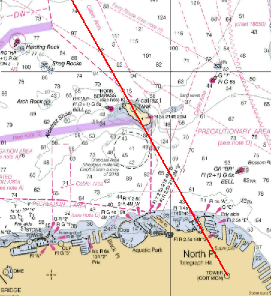
In the second example, the Alcatraz Island tank and Coit Tower are in range. You must be north of Alcatraz, somewhere on the red line.
Label range LOPs with the time.
Ranges are often set up with the goal of assisting vessel navigation.
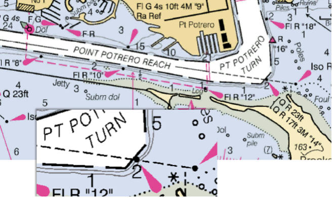
Two lights set at different heights have intentionally been placed in range at the end of the Point Potrero Reach to provide a line of position along the center of the dredged channel.
Depth Contour Line
Do you have an accurate depth sounder? If so, the chart may be able to provide you with a pre-printed LOP.
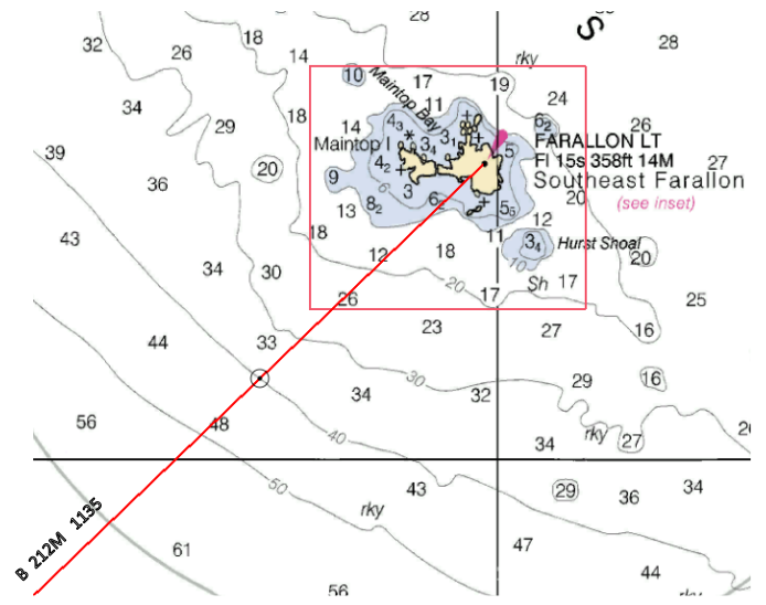
Combining a bearing to an object and a depth reading provides a location fix. Here, a 212M bearing to Farallon Lt taken at 1135 is plotted and compared to a depth sounding of 240 feet (40 fathoms)
The resulting fix places you 1.9 miles from Southeast Farallon Island.
Distance Off
Use relative bearings and their change over time to calculate distance off.
Relative Bearings
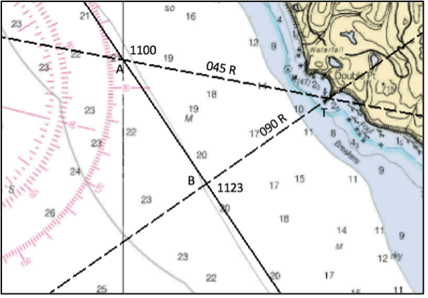
A relative bearing is the angle to an object relative to the heading of the boat. If your boat is traveling in a direction of 145T, and the bearing to an object is 100T, its relative bearing to you is 045°. This is the perfect scenario to determine distance off.
Double the Angle Off the Bow
Continue on the same heading watching the relative bearing to the object change over time. When the relative bearing is 090° determine the time required to travel from 045° to 090° relative.
Calculate the distance traveled during this time. The distance travelled is equal to the distance off the object at the time of the second bearing. This process works with any doubling of the angle off the bow.
If the relative angles are 045 and 090, it is also known as a “four-point bearing fix.”.
In the figure shown, assume it took 23 minutes to travel from point A to point B.
Using distance equals speed x time, at 5 knots, 23 minutes (.38 hours) indicates a distance travelled of 1.9nm (5 x .38 = 1.9). Therefore, the distance from B to T is 1.9nm.
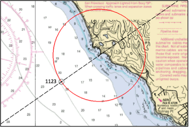
Circles Can Be Lines of Position
Now, set a divider with a pencil lead at a distance of 1.9nm and scribe a circle (or a portion of a circle) around your target.
The scribed circle is your LOP.
Added to the LOP created by the bearing of 055T to the target, you have established a location fix.
Know where 045 and 090 relative align with the structure of your vessel. If you do, distance off estimate at any time without going below or doing complicated calculations. Note the distance (or time and speed) traveled from 045R to 090R and you are done.
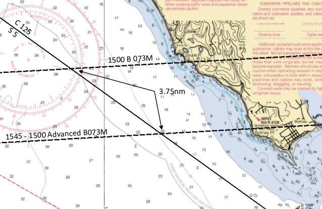
Advancing an LOP
Advancing a line of position results in something called a running fix which is covered in detail in a separate topic.
To advance an LOP, simply follow your course line the distance you have traveled over a period of time. Now, take an old LOP and move it that distance. The advanced LOP can now be used with a new LOP to provide a fix.
Radar
Radar, excels in providing the distance to an object. If available use it regularly.
The original bearing of 073 was taken at 1500. A vessel traveling at 5kts advances 3.75nm during 45 mins.
The advanced LOP is drawn parallel to the 1500 LOP, 3.75nm along the course line.