Where am I? Where am I going?
Dead Reckoning is the systematic determination of present position, based upon course and distance travelled from a known location. It is a way to find an estimated future vessel position. In fact, possibly its most important use is projecting into the near future to see hazards. As a result, avoiding dangers along the way to a destination. In other words, dead reckoning shows the best route to follow to arrive at your destination safely.
Variations on a name
No one is quite sure where the term “dead reckoning” came from. It may be a shortened version of the phrase “deduced reckoning,” which does a great job of describing the process. Sailors of old tended to be a bit lazy with their language usage. Many words and phrases got shortened. As a result, “deduced” may have become “ded.” Of course, that sounds like “dead”, and here we are. Throughout this course we will use the term dead reckoning, or the acronym DR.
Things to consider
Four factors become part of a dead reckoning plot.
- Course
- Speed
- Time
- Distance
First, a couple of definitions. Course is the intended direction of movement through the water. Heading is the direction the bow, or head, of the boat is pointed. In reality, heading and course may or may not be the same at any given point in time, however, to start we will treat them the same. Later, we will discuss variations on the idea of course such as course made good and course to steer.
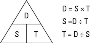
The “D Street” Triangle
Knowing how to calculate missing factors is important. A “tool” called the D Street Triangle is a great memory aid when working with Time, Speed, and Distance calculations. If you know any two you can calculate the third.
The D STreet TriangleConstructing and Labeling the Plot
Taking Departure
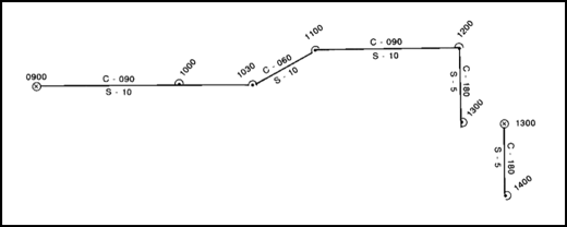
A DR plot requires a known starting point referred to as “taking departure.” This is your last known accurate position and is marked on the chart with an ⊗. The time of departure is noted horizontally on the chart. The size of the circle represents the degree of accuracy of the fix.
Items included in a DR plot
- Time of each DR and/or fix position using 4-digit military time with no punctuation (e.g. 0800 or 1500)
- Time – written horizontally for fixes, and diagonally for DR positions
- Course line (carried out for two estimated future DR positions)
- Above the course line, the letter C followed by the 3-digit course in degrees true for the ordered course (e.g. C 060).
- Vessel speed in knots (e.g. S 5)
Update the plot at least
- Once an hour, on the hour
- At every course (or speed) change
- Any time a line of position is established
- At every fix the DR plot should be reset, and a new DR plot begun
Fix Expansion
By its very nature, dead reckoning contains errors. The effects of compass error, helmsperson error, wind, and current alter your actual direction of movement through the water so that actual course achieved (course over ground – COG) differs from your intended course or heading.
DR positions are always estimates
Sea state, wind, and currents result in a different speed over ground then speed through the water. Errors may cancel each other out, or they may be cumulative, resulting in greater error. Meaning that a DR position must always considered approximate. However, a navigator must understand all possible hazards along the path of travel. They must be known and accounted for. Fix expansion is an easy method of accounting for additive error while maintaining the assumption of an accurate vessel position.
Errors in course and speed are a function of time
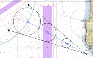
Consequently, as time passes, the error grows. To offset, the navigator incorporates an estimate of the maximum cumulative error into his plot. The he draws a circle of the appropriate size around his DR position. The area covered by each circle represents every possible position of the boat.