Navigation Charts
Any discussion of navigation publications should begin with what has to be considered the very foundation of navigation, the chart.
An Introduction to Charts
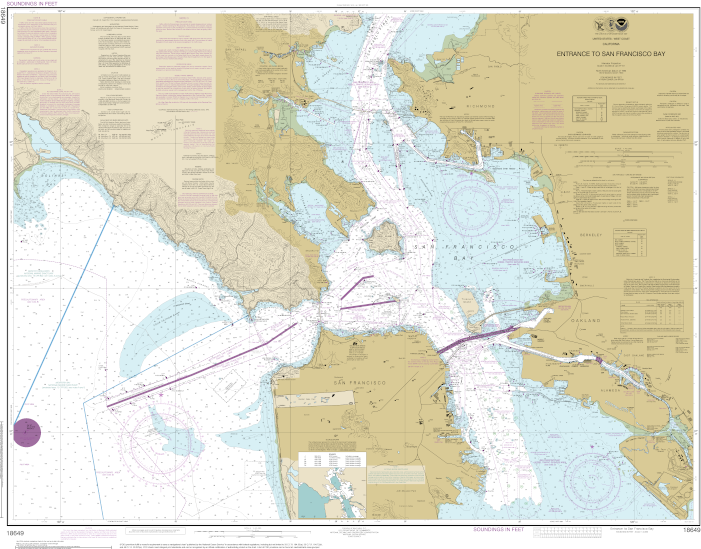
Nautical charts are essential for planning and safe navigation while underway. In the United States, nautical charts are the responsibility of NOAA’s Office of Coast Survey.
A nautical chart details information regarding water depths, bottom contours and characteristics, shoreline contours, hazards and dangers to navigation, positions and characteristics of aids to navigation, anchorages, as well as a wealth of additional information.
Charts may be obtained in either printed (referred to as vector) or electronic versions.
Electronic Navigation Charts (ENCs) may be downloaded free of charge directly from NOAA (or the United States Coast Guard).
Over a five year period, ending December 31, 2024, NOAA gradually discontinued production, maintenance, and updating of vector charts. As of January 2025, many of these “old” charts are still available through print on demand vendors, however, they may not be updated, and there is no way of telling how much longer they will be available. Fortunately, NOAA has created a custom chart tool (where members of the public can create custom paper (PDF) charts or any US waters. https://devgis.charttools.noaa.gov/pod/ .
A comprehensive discussion of the use of paper, electronic charts, and devgis.charttools follows in separate lessons.
Publications
A more complete description of Chart No. 1 and its use is explored in a later lesson.
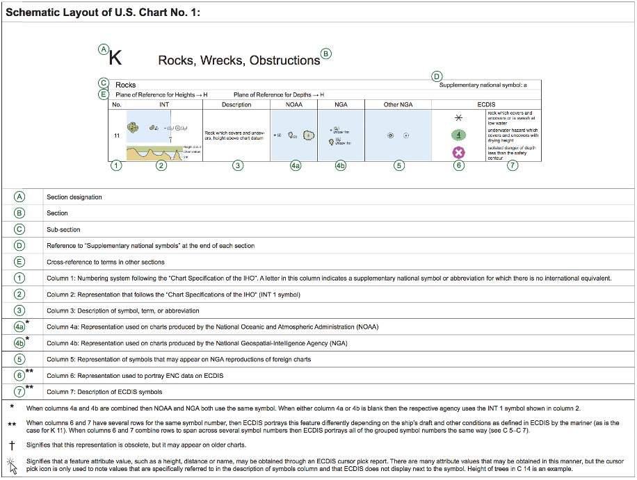
U.S. Chart No. 1
Charts, whether paper or electronic, may seem overwhelming at first glance.
There are an unbelievable number of symbols used to identify features and items of interest to a navigator. A picture of every symbol used along with a brief description of its meaning is found in U.S. Chart No. 1.
As an example, here is a representation of a single item (a Rock which covers and uncovers, height above chart datum) including descriptions of what each section refers to.
Coast Pilot
The United States Coast Pilot consists of 10 volumes covering a wide variety of information important to navigation of U.S. water. Typically, this is information that is not able to be shown in graphic form on a chart.
Information contained in each Coast Pilot includes area specific navigation regulations, visual landmark clues, channel and anchorage data, weather, currents, and navigational hazards.
Each Coast Pilot can be purchased in printed book form or downloaded for free as a PDF file. PDF downloads can be completed through NOAA’s Office of Coast Survey Publications page. https://nauticalcharts.noaa.gov/publications/coast-pilot/index.html
Planning and approach to an unknown harbor should never be attempted without a thorough review of the appropriate Coast Pilot.
National Geospatial Agency
The National Geospatial-Intelligence Agency (known by the acronym NGA) is the number one source of official publications regarding navigation. A wealth of information for the navigator is found within the webpages of Maritime Safety Information division of the NGA (https://msi.nga.mil/.)
At the time of writing, the NGA publications website may be accessed for viewing or download at “NGA Publications” (https://msi.nga.mil/Publications.)
Available publications include the following. Many NGA publications will be discussed when appropriate in this or later topics.
NGA Publications
- American Practical Navigator
- Atlas of Pilot Charts
- Distances Between Ports
- International Code of Signals
- NGA List of Lights
- Radar Navigation and Maneuvering Board Manual
- Radio Navigation Aids
- Sailing Directions Enroute
- Sailing Directions Planning Guides
- Sight Reduction Table for Air Navigation
- Sight Reduction Tables for Marine Navigation
- USCG Light List World Port Index
Links to Outside Resource Websites
Office of Coast Survey (NOAA) – https://nauticalcharts.noaa.gov/
USCG Navigation Center – https://www.navcen.uscg.gov/
National Geospatial Agency – https://msi.nga.mil/
American Practical Navigator
Also known as Bowditch, The American Practical Navigator was first published in 1802 by Nathaniel Bowditch who referred to it as the “epitome of navigation.” In my opinion, it remains that to this day.
Bowditch has been continuously updated to include advances in navigation theory and technology since its original publication. It is among the foremost guides to navigation and is a must have in any navigator’s library. As of this writing, the most recent update is the 2019 edition.
The 2019 edition of Bowditch is presented in two volumes. Volume I is “the book” itself, while Volume II includes useful tables, calculations, and a marine navigation glossary.
Both volumes, as well as 2002 and 2017 past editions are available for free download in PDF format from NGA publications.
Note: There is a “Wikisource” version of the American Practical Navigator available for viewing in HTML form. However, it is the 2002 edition, and does not include the most up to date information available.
There is a warning on the site that “The source document of this text is not known.” Downloading the PDF directly from the NGA is the better way to go.
Pilot Charts
Pilot Charts separate the world’s oceans into five regions. Each region has a separate chart for each month of the year.
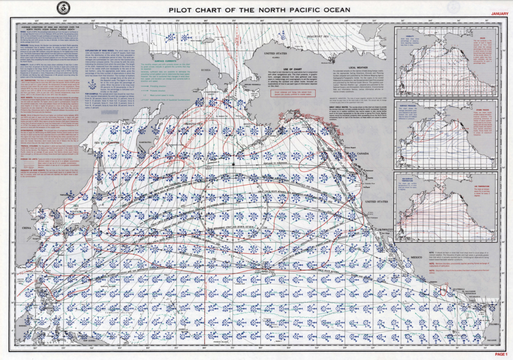
Pilot Charts include information such as typical wind direction and speed, direction and speed of ocean currents, the percentage chances of waves of 12 feet or greater, storm seasons and past storm tracks.
Sailing Directions Enroute
Containing information similar to the United States Coast Pilot, Sailing Directions Enroute are a series of publications with navigation information on non-U.S. waters.
As with the Coast Pilot, any voyage to a foreign location must include a review of Sailing Directions Enroute for that area.
For convenience of review, they may be downloaded in PDF format. I personally like to print and highlight sections which may impact my route.
Local Notices to Mariners and Notice to Mariners
Often confused, both publications contain valuable informational updates related to navigation safety. The Notice to Mariners is published by the NGA and includes information to update on all U.S. charts and publications. The Local Notices to Mariners are published individually by each of the nine U.S. Coast Guard Districts, and include very detailed and specific information relevant to each specific district.
Valuable information is found in both sets of publications, and both should be used.
Notice to Mariners
The US Notice to Mariners corrects NGA and NOS (National Ocean Service) charts using information collected from many sources, among them the Local Notice to Mariners. The US Notice to Mariners will contain only those chart corrections of interest to ocean-going vessels.
A vessel entering U.S. waters would benefit from downloading the current US Notice to Mariners.
Current and previous, Notice to Mariners may be downloaded as PDF files via https://msi.nga.mil/NTM.
Local Notices to Mariners
The Local Notices to Mariners is the primary means for providing information concerning ATONs (aids to navigation), navigation hazards, and other items of information to mariners on the waters of the United States, its territories, and possessions. These notices are essential to all navigators for the purpose of keeping their charts. Light Lists, Coast Pilots and other nautical publications up-to-date.
Local Notices to Mariners is the best resource for updating charts on specific sailing areas in US Waters.
Current and previous, Local Notices to Mariners may be downloaded as PDF files via https://www.navcen.uscg.gov/?pageName=lnmMain
International Notices
While navigating outside of U.S. waters, it continues to be important to keep abreast of changes and updates to the maritime environment. Most countries with a maritime tradition have publications similar to Notice to Mariners and/or Local Notices to Mariners. Two examples follow:
- NOTMAR – The Canadian Coast Guard Notices to Mariners
- ADMIRALTY Notices to Mariners – The British Notices to Mariners
Before operating in foreign waters, every effort should be made by a diligent navigator to obtain up to date information about the intended sailing area(s).
Light List
The name may be a bit deceiving, as the The USCG Light List (Light List) contains information on more than just lights. It is published in seven volumes and contains details about lights and other aids to navigation used for general navigation maintained by or under the authority of the U.S. Coast Guard.
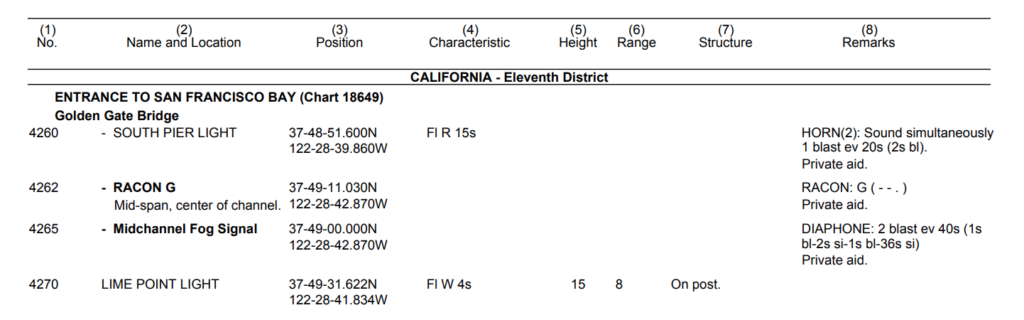
Each volume corresponds to a different regional area and contains more complete information on each aid to navigation than can be conveniently shown on charts.
What I consider to be a valuable bonus to the Light List is the abbreviation lists and glossary pages found at the beginning of each Light List publication. If you are not sure of the difference between a buoy, a beacon, and a daybeacon, this is one place to look. Or, how about the what flashing, occulting, and isophase mean.
The Light List is updated weekly and may be downloaded in PDF form.
Tide and Current Tables
The effects of moon and sun on the level of the water in our oceans, especially in the coastal areas, is very noticeable. Most coastal areas of the world experience two periods of high water, and two periods of low water each day. the volume of change depends on too many factors to easily discuss here, however, knowing the amount of change in your sailing area is critical to safe navigation! This is where tide and current table come in.
In the United States, the meaning of the phrase tide tables was turned upside down January 1, 2021. On that day, due to the availability of electronic predictions products, NOAA ended production of printed tide table publications. The final printed edition provided tide and tidal current predictions for the calendar year 2020.
Tide and Tidal Current predictions are now available through NOAA online services. While others may disagree, in my opinion, this is a good change, simplifying the process of getting tidal information for a specific area.
Today, the two primary sources of tidal information are:
- https://tidesandcurrents.noaa.gov/tide_predictions.html
- https://tidesandcurrents.noaa.gov/noaacurrents/Regions
- Both of these online pages my be reached from https://tidesandcurrents.noaa.gov/, which also includes an interactive map designed to help located site specific data.
Note: Private printing companies will still use NOAA data to print tide and current booklets specific to a given area. These “Tide Books” will have very similar appearance and included information as included in past booklets.
Cruising Guides
Cruising guides are private books and publications containing information relevant to specific areas, generally written by someone that has been there.
Some cruising guides are very good. Some, not so much. If you are headed somewhere, do a bit of research on what private cruising guides are available, which are good, and which may have the most current information. Remember, an excellent cruising guide written 20 years ago may not have the up to date information you need to be safe!
Other Publications
As you explore the world of marine navigation, you will find a large number of other publications. Publications like Nautical Almanacs, Sight Reduction Tables, and Radar Navigation Manuals. Indispensable in their place, they are not required for coastal navigation and piloting.