Danger Bearings
The idea of a “Danger Bearing” is a simple one. Unfortunately, as navigators we often try to make is more difficult than it really is. Here we explore what danger bearings are and how to use them as a prudent mariner.
A danger bearing does not take into consideration your vessel’s course, heading, or destination. It simply tells you which side of a line you are on, the “safe” side, or the “dangerous” side.
It is Like an LOP
A danger bearing is similar to a line of position. It is a bearing to an object. However, the bearing line is drawn from known safe water so that it passes to the side of a navigation danger like a submerged reef, a wreck, a breakwater, etc.
Two Examples
The first example shows the entrance to Point Potrero Reach in San Francisco Bay. The reach is guarded by a rock breakwater to the south. Obviously, the only safe way to get into the reach is by going around the breakwater. Simple during the daytime. Not so easy at night.
However, at night buoy R”6″, which sits off the end of the breakwater, flashes red every 4 seconds and makes a perfect guide into the channel.
Setting up the Danger Bearing
Use a chart to layoff a bearing to R”6″ which passes safely off the end of the breakwater.
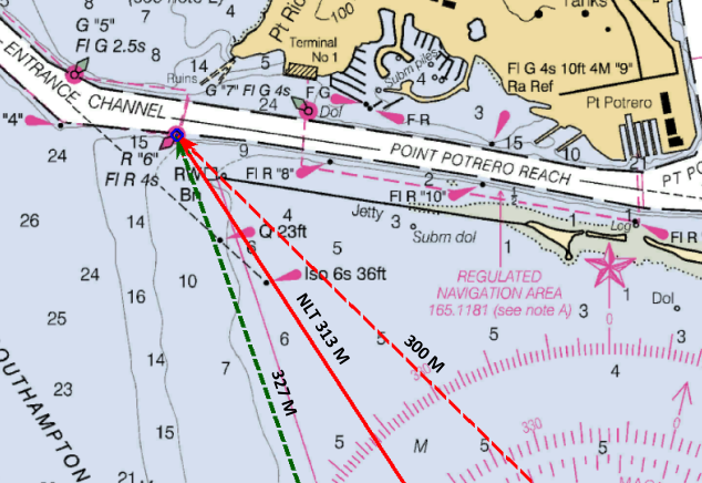
Indicated in the graphic with a solid red line, the bearing is labeled with the magnetic bearing of 313 M. The label also includes the letters NLT. More on that later. This is the “Danger Bearing”
Hopefully, it will be obvious that if you are heading toward the buoy, being on one side of the line your vessel is in safe water. The on other side of the line your vessel is heading toward the breakwater and danger.
No More Than/No Less Than
Let’s say you are on a vessel and take a bearing of R”6″. If the bearing is 300M your vessel would be on the red dashed line. If it is 327M you are on the green dashed line. Which of these would indicate danger? In this case, 300M, which is less than the 313M, would indicate danger. Which leads to the conclusion that a bearing of the buoy should never read less than 313M. On the bearing line this is notated as NLT (no less than). If danger is found on the other side of the line, the notation would read NMT (no more than)
Danger to the North
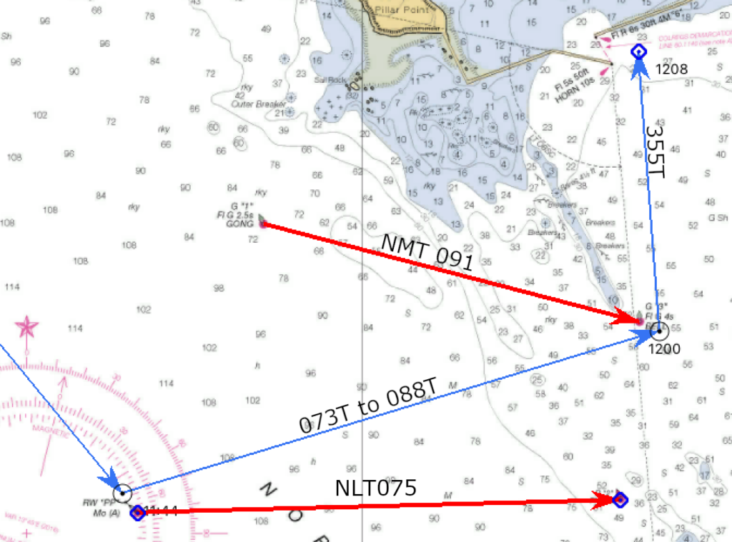
From the North or West, entering Pillar Point Harbor in Half Moon Bay requires you to travel between two submerged reefs. Day or night, use of a danger bearing assists you safely through the reefs and into the harbor.
In this case, two green buoys have been placed to mark the safe limits. A line from G”1″ to G”3″ gives a danger bearing to G”3″ of 091M. A vessel located north of that line is in danger, and would get a bearing greater than 091M. Therefore, the danger bearing into Pillar Point should be NMT 091M.
Danger to the South
Entering any strange harbor should always be done from a known point of safe water. In the case of Pillar Point Harbor, a safe water mark (RW “PP”) has be placed about 1.5 miles west of the reefs. In the graphic above, a course was laid off the “PP” where a turn to port heads through the reefs. G”3″ about is paired with R”2″. A bearing from “PP” to R”2″ provides a southerly danger bearing of NLT 075M.
Why Magnetic
I am a firm believer that all bearings marked on a chart should be in degrees True. There are two exceptions:
- Bearings relative to your vessel are always marked as relative (otherwise they would not be relative bearings.)
- Danger bearings must be marked in magnetic.
If you are in danger, you must know immediately. When checking your locations against a danger bearing, a hand held compass is used. The bearing that is read will be in magnetic. Converting to true takes valuable time better spent getting out of trouble. Mark your danger bearings in magnetic so that you recognize immediately that you are in danger.