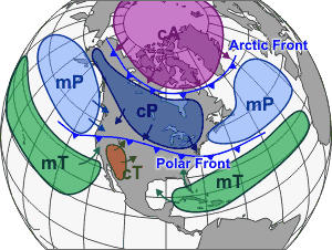
Air Masses
Temperature vs. Moisture Content
An air mass is a large volume of air defined by two basic factors. What is the moisture content and is the air warm or cold. As a result, air masses are typically broken into five basic types.
Moisture Content
Moisture content is the primary defining characteristic. Air is either Continental (c) or Maritime (m). Continental air masses form over dry land and consequently have little moisture content. Maritime air masses on the other hand, form over oceans and are therefore moist.
Temperature
Each of these air mass types are then further divided by the temperature of the area they are formed.
- Tropical (T) air masses form in the warm lower latitudes and are consequently warm in nature.
- Polar (P) air masses originate in cold higher latitudes.
- Arctic (A) air masses start out in the arctic and antarctic areas with results in extremely cold air.
The five basic air mass types
Combining these two basic air mass characteristics together results in five basic types.
- mT – Warm moist air. Formed over the oceans in lower latitudes.
- mP – Cold moist air. Formed over the oceans in higher latitudes.
- cT – Warm dry air. Formed over land in lower latitudes.
- cP – Cold dry air. Formed over land in higher latitudes.
- cA – Very cold dry air. Air is so cold in this area that it is not able to sustain any kind of moisture content. As a result, there is no maritime arctic classification.
These five basic air mass types may be further broken down by specific areas, such as “equatorial” or “monsoon”, however, it isn’t needed as part of basic marine weather knowledge.
Air masses don’t appear to form as much in the middle latitudes. Instead, the mid latitudes seem to be dominated by the movement of air masses from higher and lower latitude areas.
After formation air masses move around. Air mass movement is controlled by air flow in the upper atmosphere. As an air mass moves into a new area, it may pick up characteristics from the new area. Arctic air moving south into Canada may warm but will stay dry. That same air mass moving south over the Pacific Ocean not only warms, it picks up moisture, possibly changing enough to become a maritime polar (mP) air mass.
An introduction to fronts
The boundary where two air masses converge is known as a front. Later, we will be spending a good amount of time exploring different types of fronts and their associated weather patterns. For now, we focus on just a couple of main types.
Cold fronts and warm fronts
- A cold front is a colder air mass replacing a warmer air mass.
- A warm front is the opposite affect. Warm air replacing cold air.
- There is also a stationary front where the boundary between two air masses does not move.
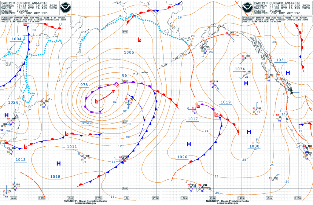
All three primary front types can be seen in this weather map. Cold fronts are identified with a blue line and blue triangles. The direction the triangle points is the direction of movement of the front. Warm fronts are indicated by red lines with red half circles in the direction of front movement.
There is a great example of a stationary front in the lower left portion of the map (running along latitude 33 to 37). There is a cold front from the north and a warm front from the south. The front boundary is marked with a line with alternates blue and red, as well as triangles and half circles.