TVMDC
Direction on the Earth can be described using relationships to the North and South Poles. Known as true north, bearings based on true north are unchanging. In the modern world of GPS, equipment can be set to calculate and display true north without additional work on the part of the navigator.
Related Pages
Unfortunately, this isn’t true when using a compass. As we will be exploring in more detail below, a compass reads “magnetic north,” a direction based on the location of the magnetic north pole in relationship to the compass location on the earth.
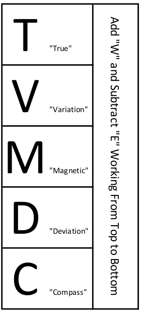
True vs. Magnetic North
Any discussion of compasses must include a dialogue about true and magnetic north. As you are all aware, the Earth rotates on an axis. The top of the axis is called the North Pole, the bottom the South Pole. A line drawn on the surface of the earth between the geographic North Pole and the geographic South Pole runs exactly North and South and is referred to as a line of Longitude.
Variation
The magnetic North Pole is not at the same point as the geographic North Pole, which means a compass needle pointing at magnetic north will not be perfectly aligned with true north. The difference between true and magnetic north is referred to as “variation” and is expressed as degrees East or West of true north.
Shown below is an example of a “compass rose” printed as part of chart no. 18649 (Entrance to San Francisco Bay). The compass rose has two superimposed compass circles, the outer circle aligned with true north, and the inner circle aligned with magnetic north.
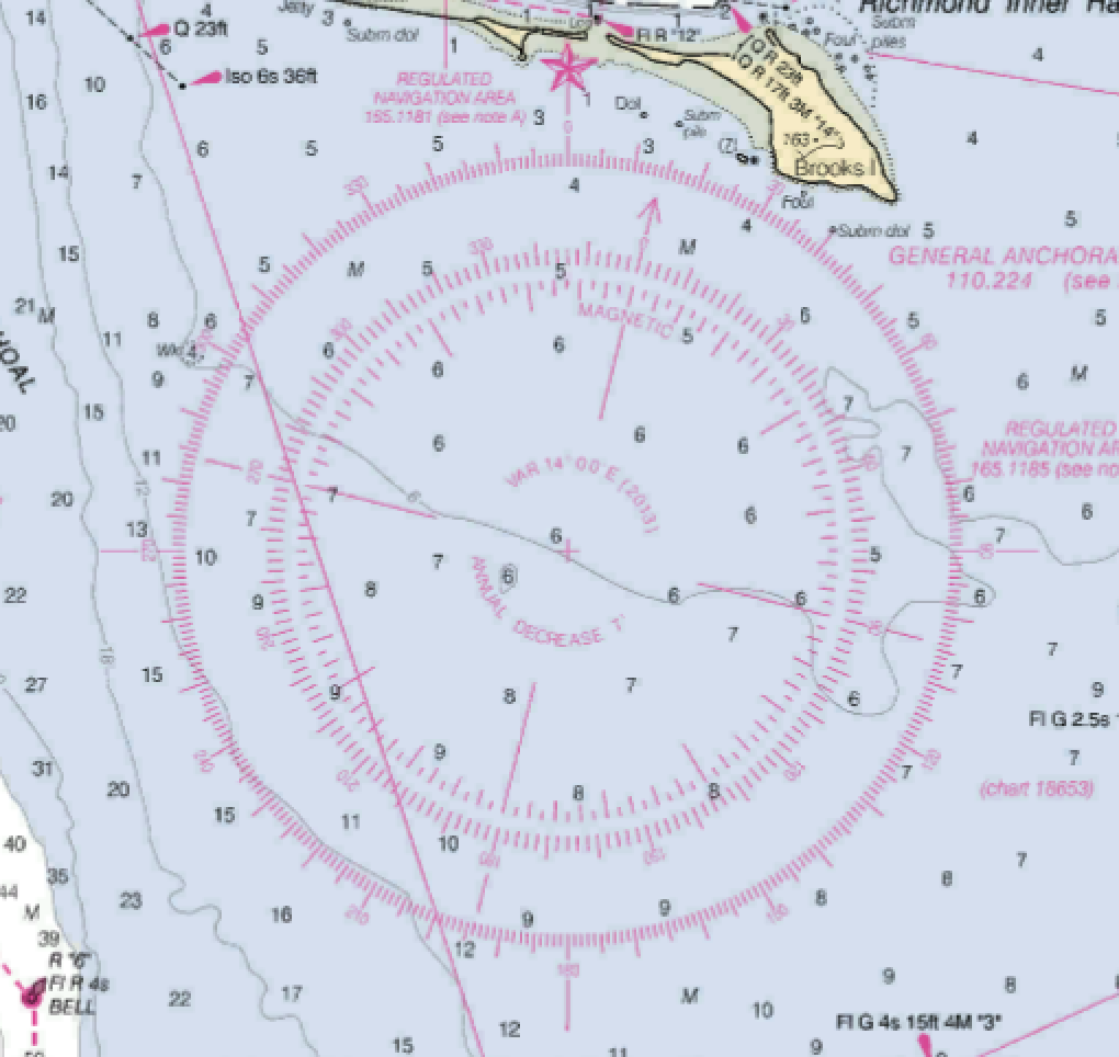
The center of the rose indicated variation (VAR). In this case, as of 2013 (the latest NOAA published chart) VAR is 14°00’ to the East of true north. Also included here is an annual change in variation, decreasing by 7’ (minutes) each year.
At the time of this writing, seven years after publication, variation would have decreased by some 49 minutes. There are 60 minutes to a degree, which in theory would make variation approximately 13°11’E in 2020. However, the amount of change is not constant from year to year, making this calculation less than exact. In fact, as of February of 2021, variation at this location is 13°19’E, approximately 8 minutes different than the calculated value.
The net result? If using the chart listed variation, don’t worry too much about adjusting it. Just use 14°E. If you have actual knowledge of what what the updated value is, then use it, rounded to the nearest whole degree. In this case, 13°E
For simplicity sake, always round to the nearest whole degree of variation.
Per Ship’s Compass
Another correction is needed when you realize no magnetic compass is entirely accurate. A compass is impacted by the environment in which it is used. A magnetic compass is mounted amongst a collection of electrical equipment and iron objects. All of which have an effect on accuracy. If you doubt this effect, watch what happens to a compass when you hold a handheld VHF radio near it. The compass needle deflects in an attempt to turn towards the magnetic influence of the radio.
Deviation
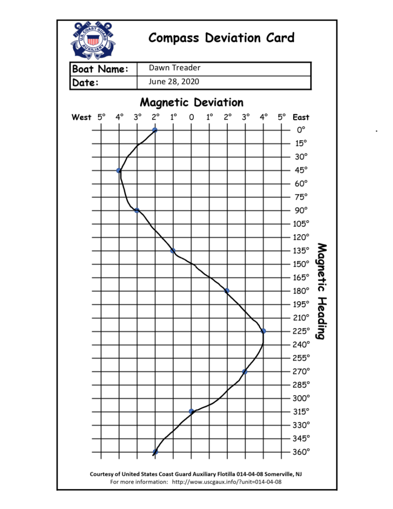
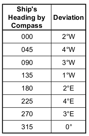
During compass installation the compass is adjusted to remove as much error as possible. However, error can not be entirely corrected. what is left is know as “deviation” and is slightly different at any direction the vessel might be headed.
How it Works
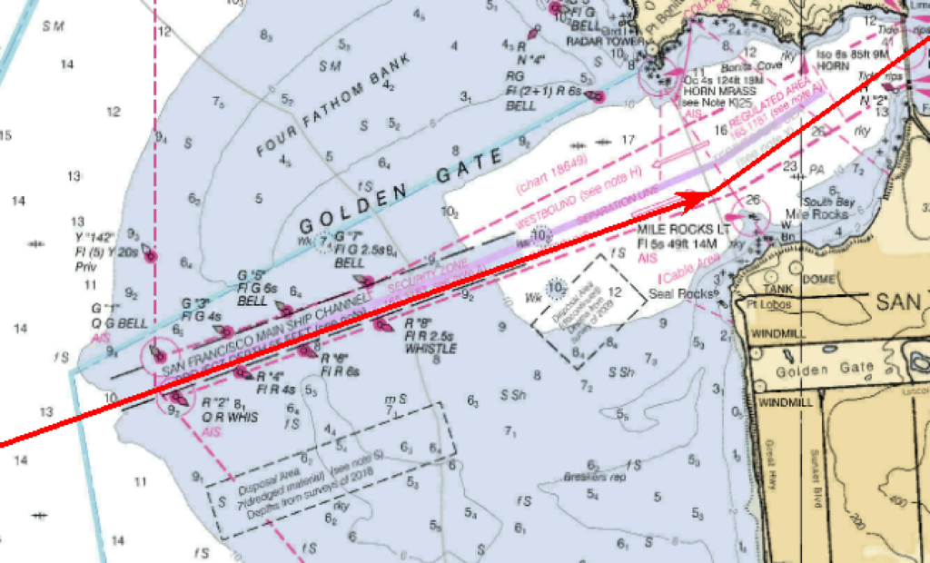
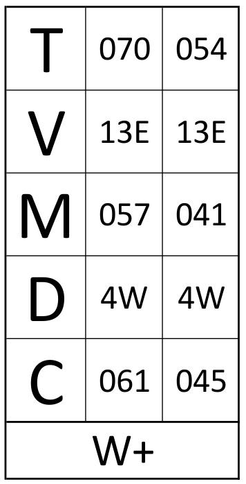
In the example above, a course plotted from the San Francisco approach buoy through the San Francisco Main Ship Channel and under the Golden Gate Bridge requires a course of 070T until the Point Bonita Lighthouse is abeam on the port side, then a course change to 054T passing under the bridge.
Subtracting the San Francisco area variation of 13E, the magnetic courses would be 057M and 041M
The deviation card above indicates a bit less than 4W for each of those magnetic courses. Rounding to the nearest whole degree of deviation results in adding 4W to each. Course to steer would be 061 PSC and 045 PSC.
