Global Circulation
An Island in the sun

Back to our island in the sun image. Although not apparent in the image, the rays of the sun do not directly heat the atmosphere. Instead, the sun’s rays heat the land, which in turn heats the air. It’s clear from this small-scale model the sun is the driving force behind the movement of air in this case. But, how about on a larger, global scale. Is the sun still the motivating factor? Yes!
Hadley Cells
The more directly the rays of the sun impact the Earth, the more energy is transferred, heating the Earth and the atmosphere above it. The sun is located more or less over the equator (more on that later.) The portion of the Earth’s surface near the equator is heated more causing it to rise vertically.
Image by NASA
Hadley cells are the basis for our understanding of global-scale meteorology.
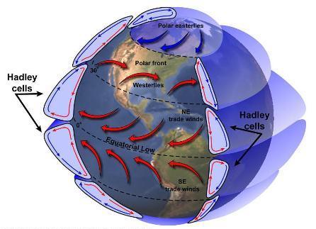
The heated air from the equator begins to move toward the poles and to cool. As the air cools, it begins to descend back to the Earth’s surface. The cooling air descends about latitude 30, causing a “pile” of extra air to end up at that location. This is referred to as an area of high pressure. As the cooled air reaches the Earth’s surface it heads back to the equator. All the while, the Earth is spinning beneath the atmosphere, resulting in wind moving in a more or less Northeast to Southwest direction (in the Northern Hemisphere). These winds are referred to as the Trade Winds.
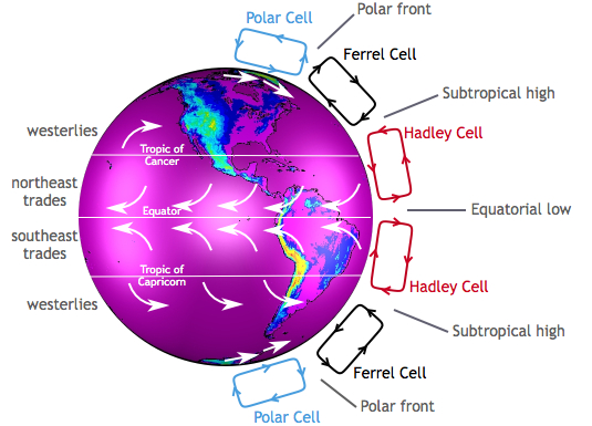
Known as a Hadley cell this movement of air forms a convection cell that dominates tropical and sub-tropical climates in the lower latitudes (0 to 30 degrees).
Ferrel Cells
Ferrel Cells are an atmospheric circulation cell occupying the mid latitudes (30 to 60 degrees). In this cell the air flows poleward and toward the east near the surface and toward the equator and westward at higher levels., rising around 60 degrees and descending around 30 degrees.
Polar Cells
With a Polar cell, the air rises from around latitude 60 and travels toward the poles. Once over the poles, it sinks, forming the polar highs. At the surface air diverges out and away from the pole. Surface winds blow from the east (polar easterlies).
Global Wind Belts
There are three global wind belts north, and three south of the equator. As mentioned earlier, located close to the equator are the Trade Winds (also known as the Tropical Easterlies), blowing from east to west. Located from around 30° to 60°are the Prevailing Westerlies coming out of the west. Finally, north and south of 60° are the Polar Easterlies.
Bands of High and Low Pressure
Between the Hadley cells and the Ferrel Cells is a band of high pressure at the surface. The high-pressure band is located about 30° North and 30° South latitude. There is also a high pressure area at each pole.
Low pressure bands are found at the equator and 50° to 60° North and South latitude
Hot and dry weather is associated with high pressure. Rainy and stormy weather is associated with low pressure. The region between 50° and 60° latitude (north and south) tends to have more precipitation due to more storms moving around the earth at these latitudes, especially along the west coast of continents. Many of the Earth’s desert areas are located along latitude 30°, and large high pressure areas are found there in the middle of oceans.
Seasonal Changes
Due to the tilt of the Earth, the sun is directly over the equator only twice a year, on about March 20th and September 22nd. During the summer and winter, the sun slowly “moves” north and south of the equator to a maximum of 23.44° north on about June 21, and 23.44° south on about December 21 . The maximum latitude marking the sun’s location is known as the Tropic of Cancer in the north, and the Tropic of Capricorn in the south. The tropics lie between the Tropic of Cancer and the Tropic of Capricorn. North and south of that are the temperate zones.
As the sun moves, the Hadley Cells, Ferrel Cells, and their associated high and low pressure systems also move. The perfect example is the semi-permanent North Pacific High. Center about latitude 30, the North Pacific High moves north in the summer to roughly 38°.
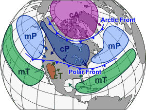
Air Masses
One final topic to introduce is air masses. An air mass is a volume of air covering hundreds or even thousands of square miles. It’s defined by its temperature and water vapor content, and falls into one of five types. Understanding air mass types becomes important later on when we discuss fronts.
Maritime Tropical (mT) air masses form over warm water areas of the tropics, and consist of warm moist air. When you think of Maritime Tropical, think hot and humid.
As the name suggests, Maritime Polar (mP) air masses form over cooler marine environments, and are responsible for cloudy damp weather.
Continental Tropical (cT) Continental tropical air masses are hot and dry. They usually form over a desert area during summer.
Continental Polar (cP) consists of cold and dry air. These often dominate the weather picture across the USA during winter. These air masses are the ones responsible for bringing clear and pleasant weather during the summer to the north.
Except in rare circumstances, a Continental Arctic (cA) air mass is not of concern to the typical sailor. An Arctic air mass is identified by extremely cold temperatures and very little moisture. These usually originate north of the Arctic Circle, however during winter may plunge south.